Navionics Platinum Plus 912PP - US West Coast - Hawaii - SD Card MSD/912P+
$426.44
Out of stock
SKU
JMS171041
NAVIONICS PLATINUM PLUS 912PP US WEST COAST SD
912PP
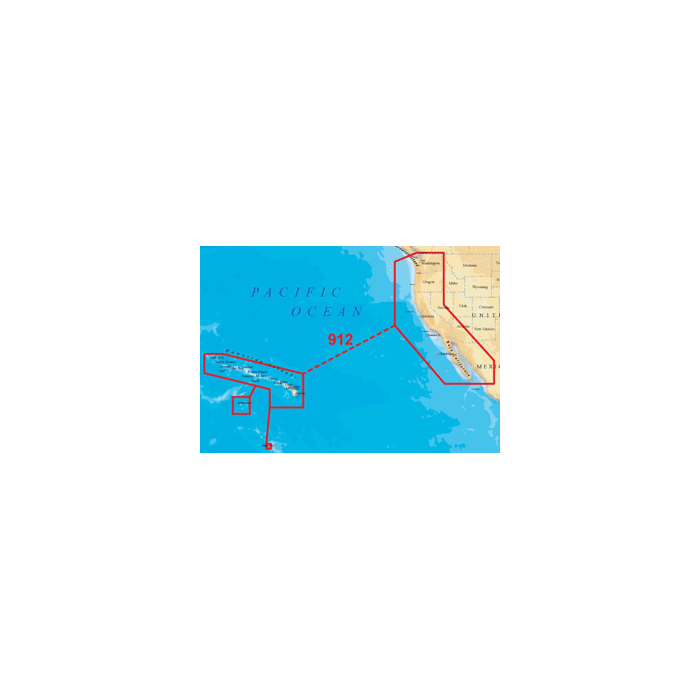
US WEST COAST-HAWAII
PUGET SOUND, WASHINGTON, OREGON, CALIFORNIA, BAJA, HAWAII From Vancouver, BC to Cabo San Lucas, MX, Cape Flattery and offshore bathymetric data and the entire chain of the Hawaiin Islands. Includes the Columbia River from the entrance to Lake Wallula/Snake River entrance.
Platinum + Charts
The most advanced technology and best imaging available in multi-dimensional charts
Improved 3D View
With enhanced bottom contour profiles and high-resolution photo overlay
Contiguous Satellite Photo Overlay
The best available high-resolution top-down satellite and aerial photo overlays
Allows comparison with chart information improving situation awareness
Helps anglers find the skinniest of water not available on any electronic chart
Brilliant Panoramic Pictures
Harbors, marinas, ports and passes in full-view XGA
Enhanced Port Services
Access detailed information, including phone numbers, for services and points-of-interest available near port
Plus major coastal road networks to help you find your way from port to points-of-interest
Complete NOAA Coast Pilot
Volumes of available navigation information such as channel and wharf descriptions, anchorages and bridge clearances, all geo-referenced to your current position
Tides & Currents
Access tidal heights, flow speed and direction, for today"s fishing trip or next week"s cruise down the coast
Plus, FREE Fish"N Chip
The best high-definition fishing detail available for your chartplotter, included free on your Platinum+ Chart (for US waters only)
Compatible Plotters:
Humminbird:955C 957C 967C 3D 997C SI 1197C SI 1157C 1155C
Lowrance:HDS-10/HDS-10M HDS-8/HDS-8M HDS-7/HDS-7M HDS-5/HDS-5x/HDS-5M
Raymarine:E120 E80 GPM400
US WEST COAST-HAWAII
PUGET SOUND, WASHINGTON, OREGON, CALIFORNIA, BAJA, HAWAII From Vancouver, BC to Cabo San Lucas, MX, Cape Flattery and offshore bathymetric data and the entire chain of the Hawaiin Islands. Includes the Columbia River from the entrance to Lake Wallula/Snake River entrance.
Platinum + Charts
The most advanced technology and best imaging available in multi-dimensional charts
Improved 3D View
With enhanced bottom contour profiles and high-resolution photo overlay
Contiguous Satellite Photo Overlay
The best available high-resolution top-down satellite and aerial photo overlays
Allows comparison with chart information improving situation awareness
Helps anglers find the skinniest of water not available on any electronic chart
Brilliant Panoramic Pictures
Harbors, marinas, ports and passes in full-view XGA
Enhanced Port Services
Access detailed information, including phone numbers, for services and points-of-interest available near port
Plus major coastal road networks to help you find your way from port to points-of-interest
Complete NOAA Coast Pilot
Volumes of available navigation information such as channel and wharf descriptions, anchorages and bridge clearances, all geo-referenced to your current position
Tides & Currents
Access tidal heights, flow speed and direction, for today"s fishing trip or next week"s cruise down the coast
Plus, FREE Fish"N Chip
The best high-definition fishing detail available for your chartplotter, included free on your Platinum+ Chart (for US waters only)
Compatible Plotters:
Humminbird:
Lowrance:
Raymarine:
| UPC Code | 821245912572 |
|---|---|
| Manufacturer Part Number | MSD/912P+ |
| Manufacturer | Navionics |
Write Your Own Review
We found other products you might like!